Earthquakes today

Current and latest world earthquakes breaking news, activity and articles today

Minor World Earthquakes Magnitude -3.9

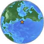
Minor earthquake, 3.7 mag was detected near Tanaga Volcano in Alaska


Earthquake location 51.35S, -178.0199WA minor earthquake magnitude 3.7 (ml/mb) has struck on Monday, 59 km S of Tanaga Volcano, Alaska (37 miles). The earthquake occurred at a depth of 28.3 km (18 miles). The 3.7-magnitude earthquake has occurred at 18:20:54 / 6:20 pm (local time epicenter). Exact location of earthquake, -178.0199° West, 51.35° North, depth 28.3 km. Event ids that are associated to the earthquake: ak11620670, us20002pmj. Id of event: us20002pmj. Global date and time of event UTC/GMT: 09/06/15 / 2015-06-09 03:20:54 / June 9, 2015 @ 3:20 am.

Every year there are an estimated 130,000 minor earthquakes in the world. In the past 24 hours, there have been four, in the last 10 days ten, in the past 30 days fifteen and in the last 365 days eighty-one earthquakes of magnitude 3.0 or greater that have been detected in the same area. Earthquakes 3.0 to 4.0 are often felt, but only causes minor damage.

Did you feel the quake?

How did you respond? Did any furniture slide, topple over, or become displaced? Leave a comment or report about activity, shaking and damage at your home, city and country. This data comes from the USGS Earthquake Notification Service. Read more about the earthquake, Seismometer information, Distances, Parameters, Date-Time, Location and details about this quake, that has occurred near: 59 km S of Tanaga Volcano, Alaska.

Copyright © 2015 earthquakenewstoday.com All rights reserved.


More information

Parameter Value Description
Magnitude 3.7 mb The magnitude for the event.
Longitude -178.0199° West Decimal degrees longitude. Negative values for western longitudes.
Latitude 51.35° North Decimal degrees latitude. Negative values for southern latitudes.
Depth 28.3 km Depth of the event in kilometers.
Place 59km S of Tanaga Volcano, Alaska Textual description of named geographic region near to the event. This may be a city name, or a Flinn-Engdahl Region name.
Time 2015-06-09 03:20:54 Time when the event occurred. UTC/GMT
Updated 2015-07-03 00:48:55 Time when the event was most recently updated. UTC/GMT
Timezone offset -540 Timezone offset from UTC in minutes at the event epicenter.
Felt 0 The total number of felt reports
CDI 1 The maximum reported intensity for the event.
MMI The maximum estimated instrumental intensity for the event.
Alert Level The alert level from the PAGER earthquake impact scale. Green, Yellow, Orange or Red.
Review Status reviewed Indicates whether the event has been reviewed by a human.
Tsunami 0 This flag is set to "1" for large events in oceanic regions and "0" otherwise. The existence or value of this flag does not indicate if a tsunami actually did or will exist.
SIG 211 A number describing how significant the event is. Larger numbers indicate a more significant event.
Network us The ID of a data contributor. Identifies the network considered to be the preferred source of information for this event.
Sources ,ak,us, A comma-separated list of network contributors.
Number of Stations Used The total number of Number of seismic stations which reported P- and S-arrival times for this earthquake.
Horizontal Distance 0.484 Horizontal distance from the epicenter to the nearest station (in degrees).
Root Mean Square 1.08 sec The root-mean-square (RMS) travel time residual, in sec, using all weights.
Azimuthal Gap 203 The largest azimuthal gap between azimuthally adjacent stations (in degrees).
Magnitude Type ml The method or algorithm used to calculate the preferred magnitude for the event.
Event Type earthquake Type of seismic event.
Event ID us20002pmj Id of event.
Event Code 20002pmj An identifying code assigned by, and unique from, the corresponding source for the event.
Event IDS ,ak11620670,us20002pmj, A comma-separated list of event ids that are associated to an event.

Leave a Reply