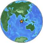
 A major earthquake with magnitude 7.9 (ml/mb) was reported Southwest of Sumatra, Indonesia (0 miles) on Wednesday. Exact time and date of earthquake 02/03/16 / 2016-03-02 12:49:46 / March 2, 2016 @ 12:49 pm UTC/GMT. Exact location, longitude 94.2358° East, latitude -4.9046° South, depth = 10 km. The 7.9-magnitude earthquake has occurred at 18:49:46 / 6:49 pm (local time epicenter). The earthquake was roughly at a depth of 10 km (6 miles). Event id: us10004u1y. Ids that are associated to the earthquake: us10004u1y. A tsunami warning has been issued near Sumatra in Indonesia (Does not indicate if a tsunami actually did or will exist).
In the past 24 hours, there have been one, in the last 10 days one, in the past 30 days one and in the last 365 days one earthquakes of magnitude 3.0 or greater that has occurred nearby. Earthquakes 7.0 to 7.9 may cause serious damage. Every year there are an estimated 15 major earthquakes in the world.
Close country/countries/cities that might be effected, Bali, Banda Aceh, Bandung, Cocos Islands, Dili, East Timor, Indonesia, Jakarta, Kuala Lumpur, Malaysia, Medan, Muara Siberut, Padang, Pariaman, Singapore, Solok, Sri Lanka, Sumatra.
Did you feel the quake?
Did objects rattle, topple over, or fall off shelves? Leave a comment or report about activity, shaking and damage at your home, country and city. Read more about the earthquake, Distances, Seismometer information, Date-Time, Parameters, Location and details about this quake, that has struck: Southwest of Sumatra, Indonesia. This data comes from the USGS Earthquake Notification Service.
Copyright © 2016 earthquakenewstoday.com All rights reserved.
Afendy
REUTERS: A massive and shallow earthquake struck on Wednesday off the west coast of the Indonesian island of Sumatra, a region devastated by the 2004 Indian Ocean quake and tsunami, and there were early reports of deaths.
A tsunami alert was called off, TV said. Neighboring Australia issued a tsunami watch for parts of its western coast and then canceled it.
“There are some who have died,” said Heronimus Guru, the deputy head of operations with the National Search and Rescue Agency. He did not know how many, but any rescue operation will be hampered by the dark, which falls early in the tropical archipelago.
There were no immediate reports of damage, but the shallower a quake, the more dangerous it is. The U.S. Geological Survey originally put the magnitude at 8.2, and then 8.1, before lowering it to 7.9.
The epicenter was 808 km (502 miles) southwest of Padang, USGS said. It was 10 km (six miles) deep.
“So far there have been no reports (of damage),” Andi Eka Sakya, an official of the National Meteorological Agency, told TVOne. “In Bengkulu (on the southwestern coast of Sumatra) they didn’t feel it at all.”
President Joko Widodo was staying overnight at a hotel in Medan in North Sumatra and was safe, palace officials said. A Medan resident said he did not feel the quake.
Erwin, a resident of Mentawai, a chain of islands off Sumatra, told Metro TV: “I am at the beach currently looking to see any tsunami sign with my flashlight. There’s nothing. A few minutes have passed but nothing, but many people have already evacuated to higher places.”
Kompas TV said patients at hospitals in Padang were being evacuated. A TVOne reporter said Padang residents were panicking and there were heavy traffic jams.