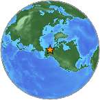
 A minor earthquake with magnitude 3.2 (ml/mb) was detected on Friday, 65 km SSW of Kaktovik, Alaska (40 miles). Exact location of earthquake, longitude -144.2063 West, latitude 69.5815 North, depth = 0.1 km. Date and time of earthquake in UTC/GMT: 19/10/18 / 2018-10-19 17:14:15 / October 19, 2018 @ 5:14 pm. The temblor was picked up at 08:14:15 / 8:14 am (local time epicenter). The epicenter was at a depth of 0.1 km (0 miles). Event id: ak20287556. Ids that are associated to the earthquake: ak20287556.
Each year there are an estimated 130,000 minor earthquakes in the world. In the past 24 hours, there have been three, in the last 10 days twenty-one, in the past 30 days fifty-seven and in the last 365 days five hundred and sixty-eight earthquakes of magnitude 3.0 or greater that have been detected in the same area. Earthquakes 2.5 to 3.5 are often felt, but only causes minor damage.
Did you feel it?
Did objects rattle, topple over, or fall off shelves? Leave a comment or report about activity, shaking and damage at your home, country and city. This information comes from the USGS Earthquake Notification Service. Read more about the earthquake, Seismometer information, Date-Time, Location, Distances, Parameters and details about this quake, recorded: 65 km SSW of Kaktovik, Alaska.
Copyright © 2018 earthquakenewstoday.com All rights reserved.
Leave a Reply